
Thus wrote the journalist James Hopper, summing up the mood in San Francisco after a magnitude 7.8 earthquake ripped through the city. The disaster claimed more than 3,000 lives and reduced the self-styled Paris of the West to ruins. In his dispatches, Hopper described the moment he was jolted awake at 5:12am on 18th April 1906:
Right away it was incredible — the violence of the quake. It started with a directness, a savage determination that left no doubt of its purpose. It pounced upon the earth as some sidereal bulldog, with a rattle of hungry eagerness. The earth was a rat, shaken in the grinding teeth, shaken, shaken, shaken, with periods of slight weariness followed by new bursts of vicious rage.
The cause of the catastrophe was the San Andreas Fault — arguably the most famous fault in the world — which ruptured from an offshore source for nearly 300 miles. The shock was so powerful, it was felt as far away as central Nevada. It tilted buildings at drunken angles, threw trains from their tracks, permanently diverted a river and crushed its victims in a chaos of dust and rubble.
Worse was to come. San Francisco was built to burn, with many timber-framed houses hastily put up in the decades following the Gold Rush. Ruptured gas mains ignited block after block and the flames merged to form a firestorm that swept the city. The wealthy mansions on Nob Hill, the iconic City Hall — built just seven years before — and the first incarnation of the Palace Hotel were all lost to the conflagration. At the California Academy of Sciences, botany curator Alice Eastwood managed to save almost 1,500 plant specimens, including hitherto undiscovered species, before the remainder was reduced to ashes. Those who survived the shaking were simply incinerated if they couldn’t get out in time.
The fire was most memorably captured in Arnold Genthe’s photograph (pictured above) taken on that same morning of 18th April, a few hours into the unfolding disaster. The image depicts San Franciscans in fine Victorian attire, gazing down the hill of Sacramento Street at the smoke wafting from the buildings below. The onlookers are apparently oblivious to the fact that the flames are burning towards them, not away from them. As Genthe himself later recalled: “Several people upon seeing [the photograph] have exclaimed, ‘Oh, is that a still from a Cecil De Mille picture?’ To which the answer has been, ‘No, the director of this scene was the Lord himself.’”
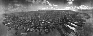
The inferno swallowed up Sacramento Street and then raged on for four days and nights. When it finally burnt itself out, there was nothing left standing in its wake. In the words of the acclaimed novelist Jack London: “An enumeration of the buildings destroyed would be a directory of San Francisco.” A panorama (below) shot from an airship above the waterfront shows the full scale of the calamity: 80% of the city reduced to cinders, a Californian dream literally up in smoke.
Monday marked the 110th anniversary of the great San Francisco earthquake and in the intervening century or so, seismology has grown into a fully-fledged science. In 1906 the discipline was in its infancy. Theories about the origin of earthquakes had abounded since the time of Plato, but the actual geological mechanisms at work were poorly understood.
That all changed when the Californian government commissioned a report to study the 1906 earthquake in a bid to understand its causes and effects. The famous Lawson report, as it came to be known, documented the event in forensic detail and is still used by modern scientists and historians as an important account of 1906. Unprecedented in its scope and scale, the investigation became a watershed moment in geology.
One of the report’s authors, Harry Reid, saw how the earthquake had caused offsets in fences, railroads and pavements all along the rupture of the San Andreas Fault. Reid’s findings led him to propose his elastic rebound theory, which argued that earthquakes occur because of strain accumulating on rocks on either side of a fault. Like a tug of war, the strain builds until eventually the rocks snap and the fault is displaced. Elastic rebound theory was the most significant breakthrough in seismology until the development of plate tectonics in the 1960s.
The implications of the Lawson inquiry were clear and far-reaching. It established the geological threat faced by the Bay Area and implicitly warned that future tremors could devastate the region to the same extent as 1906, if not greater. Yet the report was more or less ignored by the authorities. Keen to protect San Francisco’s reputation, they were worried that any seismic hazards would drive away business. Fire losses were insurable but earthquake losses were not, so vested interests orchestrated a systematic cover-up. Photographs were retouched to emphasise the effects of fire rather than earthquake. Newspapers were instructed to refer to “the Great Fire” rather than “the Great Earthquake.” The official death toll of 498 was a wild understatement: it’s now believed the real figure may be as much as six times higher. The San Andreas Fault was simply removed from the state geological map of California. Business was quick to return and the Bay Area’s population exploded.
At the same time as San Francisco rose from the ashes, it remarkably experienced no major earthquakes for the best part of a century. Geologists call this a ‘stress shadow’: the 1906 quake was so energetic that it released the pressure on all the faults that make up the San Andreas system. Compared to pre-1906, modern San Francisco has been relatively quiet. The stress shadow conspired with institutionalised denial about the risks of earthquakes, leaving many residents vulnerable to further catastrophes. In fact in the post-1906 construction boom, building codes were substantially weaker than prior to 1906: a gross miscalculation.
The errors of the past returned to haunt San Francisco, when on 17th October 1989, the city was rattled again for fifteen seconds. Though it killed 63 people, left 8,000 homeless and caused billions of dollars’ worth of damage, the Loma Prieta earthquake was just a foretaste of the Big One. It registered at magnitude 6.9, a fraction of the size of the quake of 1906. And while in 1989 the epicentre was 60 miles away from San Francisco, in 1906 the epicentre was just eight. All told, the Bay Area may have got off lightly.
Perhaps too lightly. At some point the stress shadow will end and San Francisco will suffer a repeat of 1906. There will be a large earthquake, maybe as powerful as the one that decimated Ecuador last week but situated in the heart of one of the most densely populated urban areas of the United States. And then just as in 1906, there will be a fire that will raze city blocks to the ground. The potential for death and destruction on a scale far greater than that seen a century ago is chilling.
Seismologists and politicians alike are understandably alarmed by this prospect and the race is on to find the source of the next 1906. Of particular concern is the Hayward Fault, which runs parallel to the San Andreas and is part of the wider Bay Area system of faults. When it last erupted in 1868, the region was nowhere near as populated as today. Eyewitness accounts reported the ground waving like an ocean, water spurting up in the streets and chimneys knocked off every building. With an estimated magnitude of 7.0, the 1868 Hayward earthquake was considered “the great San Francisco earthquake” of its day. Now it is all but a footnote in the annals of seismological lore. Indeed, a widespread rumour persisted in the scientific community that a report on the 1868 quake had been quietly destroyed.
Earthquakes occur in cycles and the Hayward Fault ruptures about every 140-160 years. Having been silent since 1868, experts fear that it is primed to snap again soon. The fault zone is the most heavily urbanised of its kind in the US. It slices through homes, businesses and transport networks. The Hetch Hetchy aqueduct, which crosses the fault, supplies water to more than two million people in the surrounding area. Even the University of California, Berkeley, is not immune. Its Memorial Stadium is literally being torn apart by the stresses deep within the earth. Major communities such as Oakland, Fremont and San Jose are all within striking distance of the fault.
Anywhere within the Bay Area would be seriously disrupted by a Hayward earthquake, including San Francisco. As many as 1,100 roads could be out of action, stranding motorists trying to reach family members. If the 1868 event happened today, it could cause more than $120bn in economic losses. And that’s just in terms of the shaking alone; secondary effects such as fires and landslides would compound the damage. The death toll might run into the thousands. It could take months, possibly even years, to recover. Some residents could move away permanently.
The odds for such a scenario are not remote. According to the most recent estimates, San Francisco Bay faces a 72% chance of an earthquake measuring 6.7 or larger within the next 30 years. The Hayward Fault has about a 14% probability of rupturing: it is twice as likely to fail as its mighty neighbour the San Andreas. While 6.7 may sound like a completely different beast compared to an 8.0, consider that smaller quakes tend to be shallower and hence have less time to dissipate their energy before they hit the surface. (Some of the most intense ground shaking ever recorded occurred during the 2011 Christchurch earthquake, which registered at 6.3.)
What is especially worrying is that as many as 95% of affected homes and 85% of affected businesses would be uninsured. Despite the fact that California has almost become a byword for seismic hazard, earthquake insurance is still not mandatory in the state. For most people it is prohibitively expensive, because the deductibles are so high. In any case, Californians are betting their lives on a high stakes game of tectonic Russian roulette.
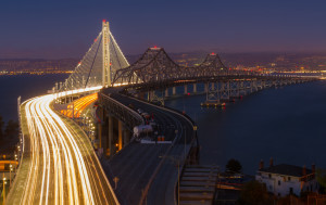
Picture courtesy of Frank Schulenberg (via Creative Commons)
Some things are being done to prepare. The eastern span of the San Francisco-Oakland Bay Bridge, which was predicted not to survive the next earthquake, has been completely replaced (above). The UC Berkeley campus has undergone major retrofitting, as have both San Francisco and Oakland City Halls. Yet in between these large capital projects, there are hundreds of thousands of smaller buildings which were erected before modern construction codes came into effect. If these are not brought up to date, they will become lethal deathtraps. An old mantra in seismological circles goes: “Earthquakes don’t kill people; buildings do.” As so many examples have shown — from Kobe in 1995 to Haiti in 2010 — structural engineering can mean the difference between lives saved and lives lost.
The other critical lesson of the past is that ground conditions matter. If urban planners were sensible, they would for instance demolish the entirety of the Marina District in San Francisco. This fashionable neighbourhood is built on landfill reclaimed from the Bay as well as (ironically enough) debris left over from 1906. Poor soil turns to quicksand during a violent earthquake, as the Marina found to its cost in 1989. Much of the rest of San Francisco, such as South of Market, also sits on loose soil that will amplify shaking. Short of relocating, these problems are much more difficult to solve.
Time may not be on San Francisco’s side. The 1906 earthquake may have gone down as the deadliest tremor yet recorded on American soil, but it could be overshadowed by a far greater calamity. The truth is that no one really knows how the Bay Area would fare if a magnitude 7.5 or 7.8 struck tomorrow. But what we do know is that it is essentially inevitable: a matter of when, not if. 1906 is a warning from history: a cautionary reminder of the perilous ground that San Francisco is built on and the almost limitless potential for human tragedy. More than a century later, let us hope that the city heeds that warning before it is too late.